Mapping microclimate temperatures in open ecosystems using UAVs: A comparison between thermal, correlative, and mechanistic approaches
Abstract
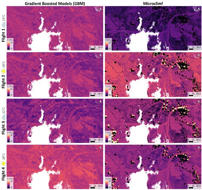
Open terrestrial ecosystems exhibit pronounced fine-scale thermal heterogeneity, yet spatially continuous microclimate data at biologically relevant heights and scales remain scarce. Here, we evaluate three unoccupied aerial vehicle (UAV)-informed approaches for mapping microclimate temperatures, including land surface temperature (LST) and near-surface air temperature (T13cm), in an open heathland ecosystem: a correlative gradient-boosted model (GBM), the mechanistic microclimate model microclimf, and UAV-based thermal remote sensing, with LST physically converted to near-surface air temperature. The comparison was conducted across four summer UAV campaigns in 2024 under clear-sky and overcast conditions, with all spatial predictor variables derived from UAV-borne thermal, multispectral, and LiDAR sensors. The GBM showed the closest agreement with in situ TOMST TMS-4 logger measurements for near-surface temperature (RMSE = 2.22 °C), followed by the UAV-based thermal conversion (2.83 °C) and microclimf (4.43 °C). Differences among approaches were systematic and land-cover-dependent: microclimf did not differ significantly from the reference in grassland but underestimated temperatures beneath solitary trees, reflecting a mismatch between its vegetation parameterization and true canopy structure, whereas the UAV-based thermal approach consistently predicted higher temperatures, reflecting both genuine surface heating and uncertainty in the LST-to-air-temperature conversion. UAV-derived thermal observations captured more extreme LST values and sharper spatial contrasts than either correlative or mechanistic models, revealing fine-scale thermal mosaics characteristic of these open ecosystems. Overall, our results demonstrate that UAV-based thermal remote sensing, particularly when integrated with multispectral and LiDAR-derived structural information and physically based temperature conversions, provides complementary value to established microclimate modelling approaches for resolving thermal extremes and spatial variability.